Maps and photos note: click or tap to see any maps or photographs below as a high resolution version.
Click or tap to zoom into map
Summary
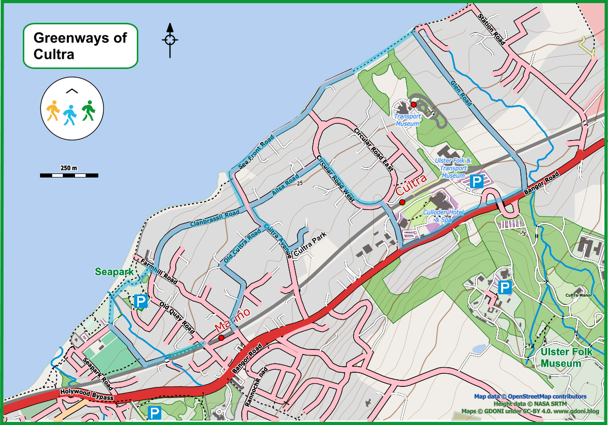
An alternative name for this walk might be ‘A Tour of the Grand Houses of Cultra’. A good place to start and finish this walk is at Marino Station – particularly if you are travelling by train to and from Holywood.
It begins with a short bramble trail (the Black Path), down the side of the railway line which takes you to the coast and Seapark recreation grounds. It then guides you past some of the grandest homes in Cultra, built on the former Kennedy estate, and back to the coastal path for some great sea views before heading up to the main Belfast to Bangor road. Here you will pass the Ulster Folk and Transport Museum and Culloden Hotel before heading down to Cultra railway station and along more tree-lined avenues to your starting point at Marino Station.
The journey, at a fairly brisk pace, will take you about 75 minutes.
TYPE
Circular walk mixed suburban and coastal scenery. Footpaths and road walking with some climbing on roads but not too steep gradients.
DISTANCE
3.65 miles / 8.1 km
SURFACES
Mostly asphalt paths and roads, but some walking on unsurfaced, potentially muddy, paths. Sturdy walking boots recommended in wet conditions and winter.
HEIGHT GAIN / LOSS
120 feet climb
HAZARDS
Some road walking on quiet suburban roads without pavements. The Black Path is narrow, muddy and quite uneven. Can be quite overgrown in summer with brambles and stinging nettles. Coastal path can be narrow in places with sheer drop down to beach. Risks in stormy weather.
Maps and photos note: click or tap to see any maps or photographs below as a high resolution version.
Click or tap to zoom into map
pro+gress n. ..6. Brit a stately royal journey.
Collins English Dictionary
To get to grips with a place it is necessary to escape its static present and seek out the flow of the natural and manmade landscape through time. When everything around you seems ordinary and now, you need to tease out the hints of history, to come to see the ground around you in a deeper dimension. Finding and travelling ‘the old ways’ is a means to do this and that is exactly what this walk tries to do!
Holywood Motte today – with its ascending helical path added in the 18th Century
TYPE
Circular walk mixed urban and countryside. Footpaths and road walking with significant climb and some steep gradients.
DISTANCE
3.2 miles / 5.2 km
SURFACES
Mostly asphalt paths and roads, but some walking on unsurfaced, potentially muddy, paths.
HEIGHT GAIN / LOSS
470 feet climb
HAZARDS
Some road walking on a quiet country road without pavements
One busy road crossing with limited visiblity
Steep slopes which could be dangerous in icy conditions
Rosamond Praeger was the only daughter among the six children of linen merchant William Praeger and his wife Maria (née Patterson). Rosamond was born on 15 April 1867, shortly before the family moved to Woodburn House on Croft Road, Holywood.
The video starts with a short overview of the history of the Dunvilles and Redburn House, this is followed by archive film of the house shortly before its demolition, then follows a series of interviews with local people who worked at the house.
Redburn Country Park A Community Guide
Produced on behalf of Holywood Shared Town, June 2017
Introduction
This guide to Redburn Country Park tells you what you can see, where you can go, and what happened here in the past. Redburn Country Park is managed by the Northern Ireland Environment Agency, and there are also various local community groups encouraging you to visit and use the park.
A Waif, cast in bronze, by the reception desk; (presented by Rosamond to Holywood Urban District Council in 1953, though first exhibited in 1906).
The Praeger Room (Ground floor, Holywood Library)
A display cabinet containing various works, including
three books by Rosamond
The Philosopher in alabaster (first made in 1913)
a bronze bust of Sir Robert Lloyd Patterson (her uncle)
a plaster relief Of Mrs D Weaving
the book Rosamond Praeger by Con Auld
On the wall
two large charcoal drawings by Rosamond (c. 1884), of James Dunlop Barbour and his daughter Gail Hilda Mary Barbour (then at Ardville in Marino)
On the window sill
The Philosopher in painted clay
a bust of an Italian Boy in painted clay
High Street
Johnny the Jig, (on a granite base carved by Holywood sculptor, Morris Harding). This was a copy of the original now in North Down Museum, erected in November 1953 at Rosamond’s wish to mark the playground donated to the town by the McCormick family.
Hibernia Street
A blue plaque erected by the Ulster History Circle on the site of her studio, St Brigid’s, at 33 Hibernia Street (replaced by the premises of the Fold Housing Association and the Ruddy Duck).
King Edward VII Memorial Hall Sullivan Place
Rosamond created the plaque above the main entrance to this 1912 building. It reads ‘Be just, temperate, brave and free’.
St Philip and St James Church Church Road
Her St Brigid plaque is on the west wall; (formerly it was above her Hibernia Street studio).
The Non-Subscribing Presbyterian Church High Street
War Memorial plaque placed (in 1922) in the central foyer of the church, along with other works by Rosamond including Angels in a Tympanum, and memorial to Lt James Dermot Neill. (The Praegers worshipped here, and Rosamond attended the School in the lower part of the Lanyon-designed building.)
The Priory Graveyard
The memorial to Rosamond’s parents (at the farthest east wall).
The Crescent
A blue plaque commemorates the birth place of William Emilius, Robert Lloyd and Sophia Rosamond Praeger. It was the first home of her parents after they married.
Woodburn House Croft Road
The home of the Praeger family from 1868 to 1891 is indicated by a blue plaque; her brothers Harry, Egmont and Owen Praeger were born here.
Praeger’s Field
The open space, inland of the Coastal Path, between Holywood and Seapark (donated by Rosamond).
Sullivan Upper School
Cartouche tablets above the main doors, (based on a bust of the founder Dr Robert Sullivan); other works and a school house named after her. Also twin reliefs over the Girls’ entrance to Sullivan Upper School.
Campbell College
War Memorial (dated 1922).
Riddel Hall Stranmillis Road
A memorial bronze (of 1915) commemorates the founders of this Hall of Residence for women students in Belfast.
Queen’s University
The monumental memorial to Rev Thomas Hamilton in the Great Hall, (who was be President of Queen’s as a College and then the first Vice-Chancellor of Queen’s University).
Ulster Museum
The Fairy Fountain (1901, in white marble); and other works not all of which are on display.
Ulster Hospital Dundonald
Bringing in the Sheaves, (a memorial bronze commemorating the first chairman of the Hospital, Ernest Boas, and his son who was killed at the Somme in 1916).
St Anne’s Cathedral
The memorial to William Reeves, of Down and Connor and Dromore (1886-92), on the north wall of the Cathedral.
North Down Museum
A dedicated display in the museum of Rosamond’s plaster-work sculptures featuring Johnny the Jig (commemorating Boy Scout Fergus Morton) and Spring.
In the Café, there is a frieze in stone called The Shawls, depicting Belfast mill workers.
Further Information
For more information and the life and work of Rosamond Praeger see Praeger in Holywood
Maps and photos note: click or tap to see any maps or photographs below as a high resolution version.
Click or tap to zoom into map
TYPE
Urban looped walk mainly along quiet residential roads. Significant climb up to the higher suburbs of Holywood
DISTANCE
2.9 miles / 4.7 km
SURFACES
Almost all asphalt paths along roads. One short section down uneven steps on a unsurfaced path which may be muddy.
HEIGHT GAIN / LOSS
360 feet climb
HAZARDS
Two road crossing points on moderately busy roads with limited visibility which require care (see map). One short section along an unsurfaced path with uneven steps.
What makes a good walk? I would go for green space, fresh air, great views, birdsong and a route with variety and interest along the way. We usually go to the countryside to find these things, but we can also get them in well designed urban environments and this butterfly shaped walk, through the high suburbs of Holywood, aims to prove the point.
You can start this walk at any point on the blue line above – I have chosen to start at the Twisel Bridge.
Live Map
From here climb up the flight of steps to Victoria Road, crossing over with care and turning right. Follow around the corner past the entrance to Glenlyon House and continue to the junction with Ardmore Park.
The “bathing villas” of Ardmore Terrace built around 1840
Looking uphill you see a 3-storey house – the end terrace of a fine set of Victorian “Bathing Villas”. These were originally intended to be let as short-term seaside holiday homes, but longer term tenants were also welcomed.
“Villas in Holywood at reduced rent. To let and immediate possession given, two houses in Ardmore Terrace. The houses have each a garden and the use of extensive grounds and contain Dining room, Drawing room and Seven Bedrooms with Hot and Cold Baths &c., and a never-failing supply of Water, without pumping. For a permanent tenant, very moderate terms would be made…An Omnibus plies from every Train, Fare 2d. Apply on the premises; or to James Greenfield, Post Office, Holywood.”
Quoted in The Griffith’s Valuation fieldbook for the period (1856-64)
Clearly the ability to commute easily to and from Belfast was as important then as now. However we are much more fortunate today in having ‘mains water’ and never having to worry about running dry!
The row would have originally looked out over a large open space (where the houses of Ardmore Park now cluster) to an uninterrupted view of Belfast Lough and the Antrim Hills behind.
The rest of the Terrace is two-storey
Head up the hill and turn left to follow the front of Ardmore Terrace. The road runs to the end of the row and turns right to join Ardmore Road.
You are now in a large area of mid twentieth century detached housing, primarily bungalows. There is much to admire here. Each house has generous gardens front and rear. There is a rich variety of garden trees, hedges and shrubs providing a shared space to enjoy for nature and walkers alike.
The big windows and broad pitched gables are very much of their time although the building materials and technology originally used left something to be desired in terms of energy efficiency. However, with modern insulation and solar roofs these homes have everything needed to be state of the art 21st century eco-houses!
Keep straight up Ardmore Road and a fine view of open country soon appears with a high tree-lined horizon. Turn right at the top T-junction with the appropriately named Ardmore Heights and continue up to the highest point of your walk (just under 300 feet above the sea visible below).
As you come to the top corner of Ardmore Heights there is a cul-de-sac ending in Woodland. This is the upper part of Glenlyon Park. Unfortunately there is currently no path to access the park from here – but this would seem to be a great option for future recreational development.
Continue along Ardmore Heights as it makes a full turn back towards Ardmore Road and Brown’s Brae beyond.
As you proceed here it is very obvious you are dropping into a valley. Valleys generally have streams in their midst and here is no exception – the Croft Burn runs hidden, but un-culverted, behind the houses lining Ardmore Road below.
Steep sided built-up areas like this are often a major cause of urban flooding when torrential rains cannot be accommodated by the limited capacity of the street drainage. However, here every garden, hedge, flower bed, lawn and shrubbery will act to absorb storm run-off and help spare other houses downstream the misery of flooding. This is in addition to cleaning the air, removing CO2, absorbing sound and providing essential habitat for birds and pollinating inserts. Neighbourhoods such as these are good neighbours indeed!
Re-joining Ardmore Road I suggest to then take the next left up Glenview Road and then into Glenmore Avenue.
Looking backward down Glenmore Avenue over Belfast Lough
At the end of Glenmore Avenue you come to a pedestrian link path which takes you through to Glenview Road.
The area was designed with houses with garages to accommodate the motor car, but it also provides good pavements and link paths for the use of walking humans. They are a balance and human focus missing in more recent developer ‘exclusive’ housing!
As you arrive in Glenview Road a fine view over the lough and Antrim Hills opens up ahead. Glenlyon Park is just to your left but again there is no access possible here.
Just before the interesting cluster of new houses at the end of Glenview Road turn right downhill into another pedestrian linkway.
This takes you out onto Ardmore Avenue and then back down to Ardmore Road where you turn left and retrace to the far end of Ardmore Terrace.
Look back now to admire the bold symmetry of the row. The houses are Victorian, but the simple geometries, balance and clean lines hark back to the Georgian style.
Now don’t return down Ardmore Park but continue past the the terrace through a pedestrian link path bearing right onto Claremont Avenue.
This is a much older roadway which takes its name from the large Victorian villa, Claremont House, which now sits on your left.
As you descend pay attention to the electric power poles on your right. I imagine the old houses of Holywood were among the early adopters of electric home lighting and many of the old metal poles from that time have survived – still fit for purpose.
Now cross Victoria Road, turn left and returning to the Twisel Bridge. Take particular care in crossing here as visibility is limited and traffic can be fast.
Follow the Twisel path keeping an eye out for white chested dippers which sometimes can be seen bobbing in the burn below. You now emerge on Church Avenue which you follow out onto Church Road. turning right and continuing uphill to pass Glenlyon Park (you will have to cross the road as the left side pavement stops short).
Further uphill, past the Glenlyon Car Park you turn into Plas Merdyn. This road is blessed with some of the finest views in Holywood.
Near the road end you will see a set of old uneven steps with a rusty handrail dropping onto a narrow pedestrian path.
Descend with care and follow the path, which can be muddy at times, down onto Demesne Grove, turning left out onto Demesne Avenue.
Now turn uphill and to the road end where a path between high hedges takes you up to Demesne Park.
There is a nice mixture of detailing in the houses here, reflecting in a small scale the fashions and thinking of their times. Open porches with decorative brickwork, high-pitched roofs, small oriel windows, stained glass and a low crisp white house with a curved metal window (which would not look out of place in a Poirot mystery).
Turn right and follow Demesne Park around the corner and downhill.
There are mercifully un-gobbled bungalows here, sitting on a height behind mature gardens. sporting bay windows with stained-glass top lights. Further down a respectful new-build sits nicely between its neighbours.
Demesne Park now joins Demesne Road. Time for a little history.
A demesne (/dɪˈmeɪn/ di-MAYN) or domain was all the land retained and managed by a lord of the manor under the feudal system for his own use, occupation, or support.
You might be forgiven for thinking that you are walking in the grounds of the original Holywood Demesne. However you would be wrong – at the closest point here you are over 200m from the once boundary wall.
Holywood Demesne was the largest by far of the estates which encircled old Holywood Town. Inside its long gone boundary walls is now the Abbey Ring Estate, Sullivan Upper School, most of the Holywood Golf Course and Nun’s Wood – the North East section of the modern Redburn Country Park. Burns Community Pharmacy and Post Office now sit (approximately) on the site of Holywood House.
So as you can see – it is not just artists who take licence with geography and history!
Turn left along Demesne Road and then right into My Lady’s Mile (just opposite a nicely updated bungalow).
Gaps in the big hedges of My Lady’s Mile reveal comfortable houses in generous gardens. However, the gap you are particularly interested in, is the entrance to a small pedestrian link path on your right which leads through to Lemonfield Avenue.
This quiet cul-de-sac with an intriguing name joins through to the junction of Demesne and Downshire Road.
To complete the looped walk now follow Demesne Road straight ahead, turn right onto Church Road and then almost immediately left back down Church Avenue to the Twisel Bridge.
Originally the square was a pleasant garden and open area for gentlemen’s carriages waiting at the railway station. The square is now the location for the town’s War Memorial dating to 1921, which was designed by L S Merrifield. It takes it’s name from Redburn House, home of Lt John Spencer Dunville of the Royal Dragoons Holywood’s only recipient of the Victoria Cross.
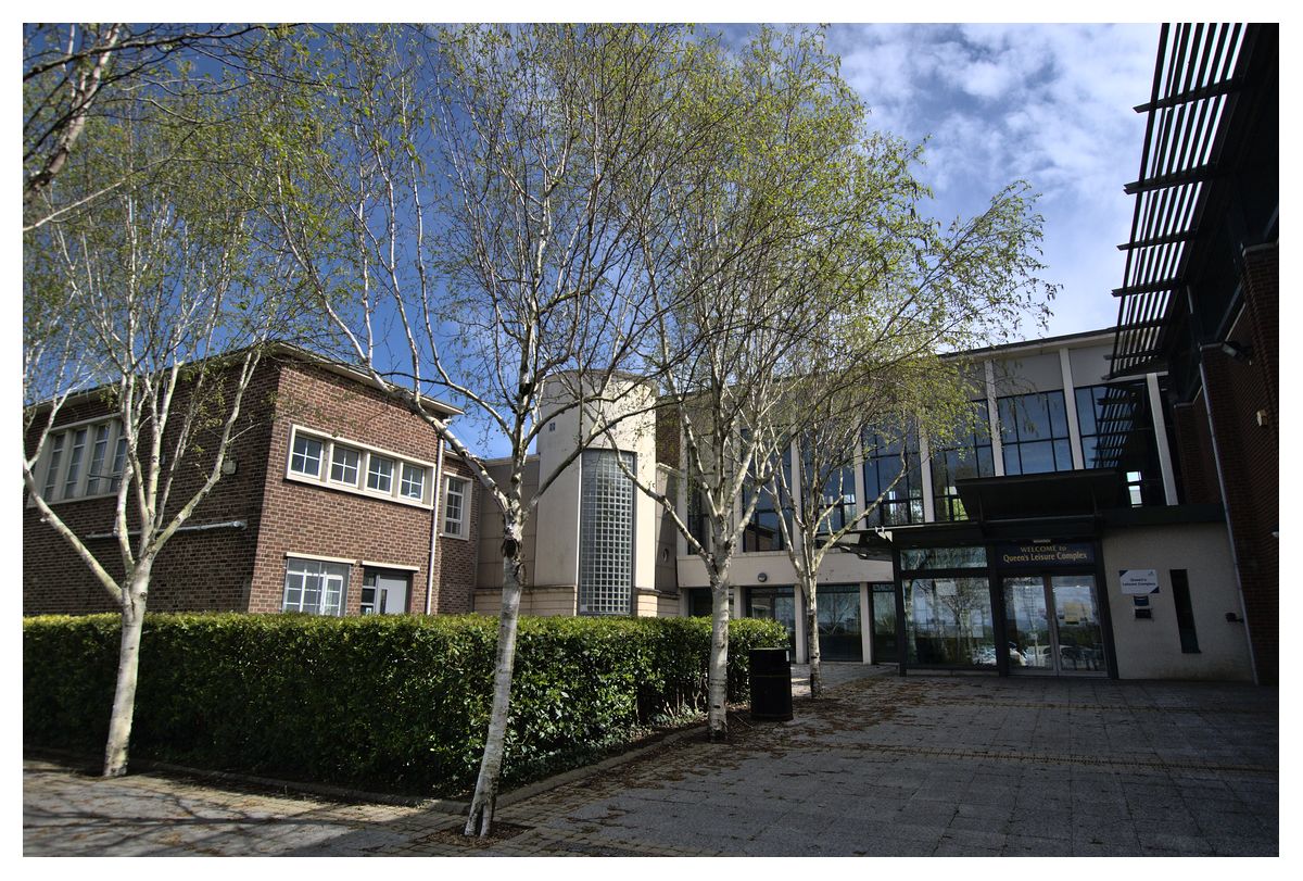
Just beyond the Fire Station are Queen’s Hall & Queen’s Leisure Complex. The hall, built in 1953 and leisure centre opened in 2000 are Holywood’s main civic buildings. A tourist information point is located at the leisure complex.
The first post-Reformation Catholic Church in Holywood was St Patrick’s in Church View which was consecrated in 1830. However, to meet the growth in the congregation Timothy Hevey was commissioned by Monsignor O’ Laverty, the parish priest, to design a much larger church on a prominent site overlooking the road into Belfast. This was in a most beautiful French Gothic style, and consisted of a nave and chancel with a lofty tower to one side, which was consecrated in 1874. The spire was added in 1891.
Sadly the church was totally destroyed by fire in August 1989 although the tower survived. The new church, which was dedicated in 1995, is circular and the belfry tower was retained. One of the most striking features of the new church is the natural light in the interior space.
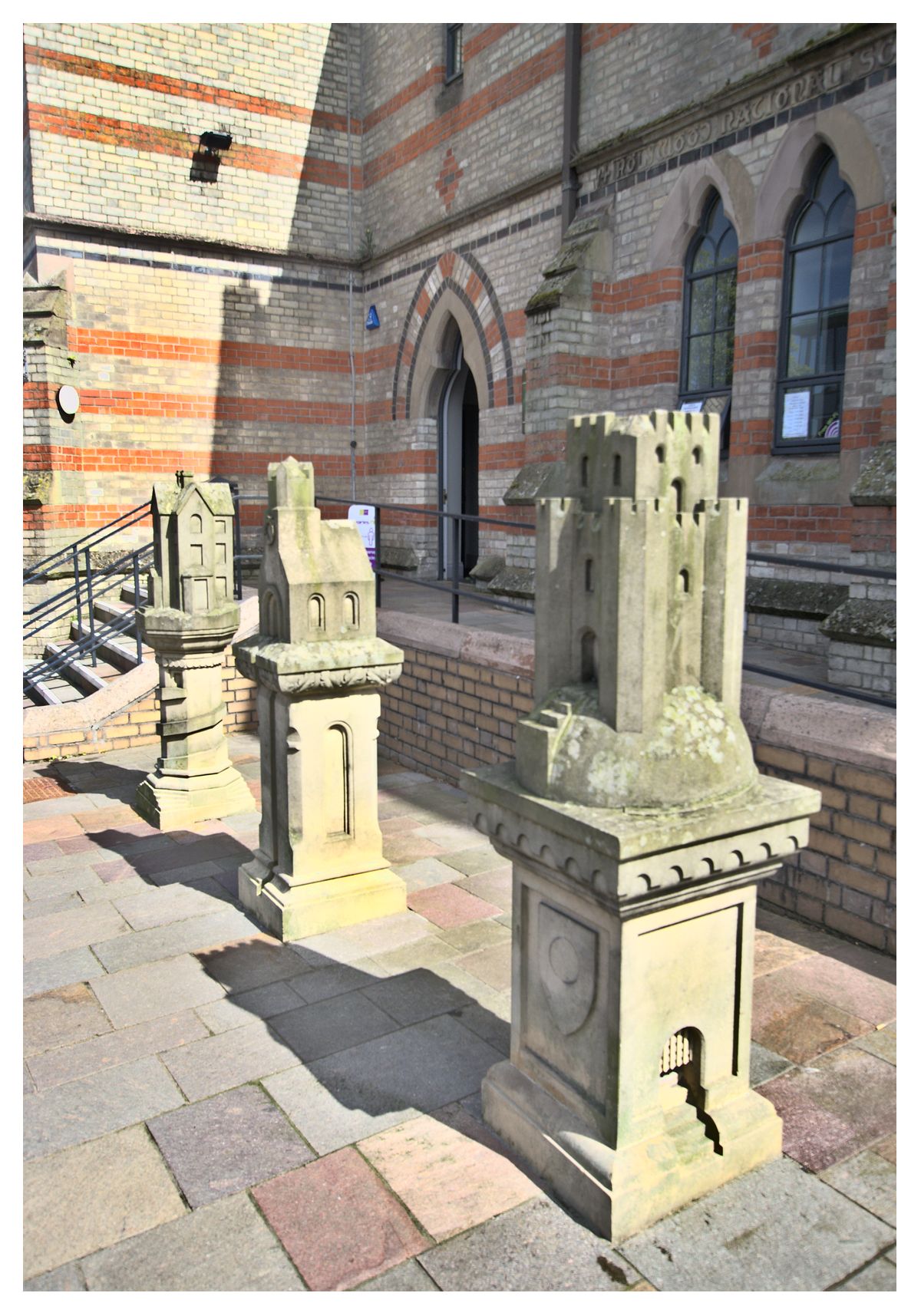
Holywood Library, a listed building, was founded as primary and secondary schools in the 1860’s. Formerly known as the Sullivan Schools, it was where the renowned 20th century naturalist and historian Robert Lloyd Praeger and his sister Sophia Rosamond Praeger began their education.
Outside the library you can see three sculptures entitled the “Pillars of Holywood” by Tim Shutter, who has worked with Anthony Gormley on a commission for the British Library. The sculptures, which were commissioned by Holywood Arts Trust and received funding through the Arts Council of Northern Ireland Lottery through the Public Art Programme, depict the legacy of the town’s 1,400-year history from the 7th century church, to the invasion of the Anglo-Normans in the 12th century and the domicile of the wealthy Belfast industrialists of the 19th century.
We use cookies on our website to give you the most relevant experience by remembering your preferences and repeat visits. By clicking “Accept”, you consent to the use of ALL the cookies.
This website uses cookies to improve your experience while you navigate through the website. Out of these, the cookies that are categorized as necessary are stored on your browser as they are essential for the working of basic functionalities of the website. We also use third-party cookies that help us analyze and understand how you use this website. These cookies will be stored in your browser only with your consent. You also have the option to opt-out of these cookies. But opting out of some of these cookies may affect your browsing experience.
Necessary cookies are absolutely essential for the website to function properly. These cookies ensure basic functionalities and security features of the website, anonymously.
Cookie
Duration
Description
cookielawinfo-checbox-analytics
11 months
This cookie is set by GDPR Cookie Consent plugin. The cookie is used to store the user consent for the cookies in the category "Analytics".
cookielawinfo-checbox-functional
11 months
The cookie is set by GDPR cookie consent to record the user consent for the cookies in the category "Functional".
cookielawinfo-checbox-others
11 months
This cookie is set by GDPR Cookie Consent plugin. The cookie is used to store the user consent for the cookies in the category "Other.
cookielawinfo-checkbox-necessary
11 months
This cookie is set by GDPR Cookie Consent plugin. The cookies is used to store the user consent for the cookies in the category "Necessary".
cookielawinfo-checkbox-performance
11 months
This cookie is set by GDPR Cookie Consent plugin. The cookie is used to store the user consent for the cookies in the category "Performance".
viewed_cookie_policy
11 months
The cookie is set by the GDPR Cookie Consent plugin and is used to store whether or not user has consented to the use of cookies. It does not store any personal data.
Functional cookies help to perform certain functionalities like sharing the content of the website on social media platforms, collect feedbacks, and other third-party features.
Performance cookies are used to understand and analyze the key performance indexes of the website which helps in delivering a better user experience for the visitors.
Analytical cookies are used to understand how visitors interact with the website. These cookies help provide information on metrics the number of visitors, bounce rate, traffic source, etc.