Category: Walks

Walks around Holywood

  • 4 Parks Walk

    Maps and photos note: click or tap to see any maps or photographs below as a high resolution version.

    TYPECircular urban walks along footpaths between and through Holywood Parks
    DISTANCE5 miles / 8 km 
    SURFACESMostly asphalt paths and roads. Short sections unsurfaced, potentially muddy, paths. 
    HEIGHT GAIN / LOSS430 feet climb 
    HAZARDSNormal urban walking hazards. Two road crossings with limited visibility where extra care is need. Two short flight of uneven steps.
    The optional full Glenlyon loop included extended flights of concrete steps.
    Three of the Parks have had their old nature based signs beautifully refreshed

    The Town of Holywood is well provided with urban parks. However, these are all small and individually only make for short walks. By joining four Parks together via a route which also visits much of the best of Holywood this walk aims to provide exercise, interest and above all beauty.

    NB the route does not include Redburn Country Park which sits on the hills above the town).

    4 Parks Walk Interactive Map

    The walk starts at the Holywood “centre of gravity” the Maypole. This crossroads defined Holywood on old maps in years gone by and today with its Maypole is still the focus of the town’s identity and festivities.

    Turn down the Main Street and follow along Holywood’s retail core on the left hand pavement.

    You soon come to a flamboyant Victorian Gothic building which currently houses Holywood Library, but was originally the Sullivan Schools.

    In front of the Library three artworks neatly summarise 1500 years of Holywood History. The three buildings represented recall the Old Priory, the Norman Motte and the Victorian suburban boom town. However, the pillars themselves echo the elaborate forms of the gateposts of the Victorian Villas. You will pass a fine example of one of these shortly.

    Leaving the shops behind, the Church of Saint Colmcille now appears on your left. Again Victorian Gothic architecture features, but here it is complemented by a bold modern building which replaced the body of the church tragically destroyed by fire in 1989.

    Crossing My Lady’s Mile road (another reference to Holywood’s long ecclesiastical past) you now come to Number 154 which has preserved its original gate pillars.

    Continue and look out across the road for Holywood CoFarm a forward looking community project working to change Holywood’s diet, health and environment for the better!

    Now in one way CoFarm is only rediscovering the wisdom of the past.

    The natives of this parish live principally by tillage. There are a few weavers and hosiers amongst them, but their employments seem to take up their time only when they cannot employ themselves in agricultural pursuits. Almost every weaver, except those who live in the village, has a piece of ground sufficient to furnish his family with potatoes, oatmeal and milk. This plan of intermixing avocations, although it may not tend to the improvement of trades or agriculture, appears to be highly serviceable to the interest of the individual, both in point of health and general comfort.

    Nothing can be more distressing than to see the pale meagre appearance of the town or city artizan, whose constitution is undermined by the sedentary life which he leads, as well as the confined air which he is obliged to breathe, and whose mind is as relaxed as his body, by the dull monotonous exercise of his calling; but when he is transplanted to the country, and employs himself occasionally in cultivating a piece of ground, the exercise and interest he feels in his occupations, give new vigour to his frame, and elasticity to his mind

    Parish of Holywood (County and Diocese of Down)by the Rev. William Holmes, Incumbent

    Excerpt from No.VII in Mason, William Shaw. A Statistical Account or Parochial Survey of Ireland, Dublin, 1819

    Passing CoFarm and the modern Sullivan School you come to the junction with Abbey Ring. You could turn left here on your way to Holywood Nature Park, but there is a much better pedestrian route alternative – so continue on the Belfast Road for a further 150m to a bus stop shelter where you turn left along a “Greenway” to enter the Abbey Ring estate as a foot traveller.

    The design of Abbey Ring pre-dates the “car park to car park” concept of the modern housing developer. The sad idea that you invariably step out of your house directly into a car and drive to another car park blights our modern suburbs. Here walking is quick, safe and pleasant. The housing is varied and incorporates private gardens and semi-communal green space.

    The Nature Park itself was once a local playing field, but the relentless trend to synthetic pitches, windowless halls and artificial light left it unloved and underused.

    So, on meeting Abbey Ring turn left and immediately right and follow West Link and on traffic free paths through the middle of the estate eventually meeting Abbey Ring again where you turn left and right into Abbots Wood.

    The north entrance to the Nature Park is 50m down Abbots Wood on the right hand side and is marked by an austere black metal post – in stark contrast to the signs of our other town parks.

    The view into Holywood Nature Park from the south entrance marked by another black obelisk

    Any good park should permit the visitor a choice of paths and a chance to find their own way. This park started life as a modest rectangular playing field, but its clever re-invention as a wildflower rich meadow fringed with snippets of woodland and the associated surfaced and mowed paths really does invite the wanderer in!

    So find your own way to the east gate and out onto Demesne Road. Turn left and follow the road for 450m to where you again cross My Lady’s Mile. On your right you will pass a number of impressive high-set houses looking out over still intact mature gardens to Belfast Lough beyond.

    After crossing My Lady’s Mile carefully cross Demesne road and take the second turning on the right into Demesne Avenue. Now turn left into Demesne Grove looking out on the right for the grassy public right of way which leads up to Plas Merdyn.

    This short cul-de-sac affords perhaps the best views over Belfast Lough of anywhere in Holywood. Turn left and follow it out to its junction with Church Road.

    Now turn left and after 50m carefully cross the busy road to enter Glenlyon car park at the top entrance (this point has clear views up and down hill unlike opposite the lower entrance).

    Glenlyon Park is primarily a narrow steep sided river valley with many flights of concrete steps. However the lower section is much flatter and also features sheltered open grassy areas which are particularly pleasant in sunny weather. The suggested route below visits most of the park but if you restrict yourself to the north end all the steps and slopes can be avoided.

    Leave the car park by the flight of concrete steps climbing up to the ridge above the Twisel valley beyond. The trees here are mainly mature conifers surrounded by dark thickets of the inevitable invasive cherry laurel. Turn right uphill and continue for 170m and take the second path to your left down a flight of steps to the river. Cross the bridge and turn right upstream.

    The vegetation here is more natural and a youngish woodland lines both sides of the valley. There are a number of pools and you will soon come to an attractive small waterfall.

    Shortly after this the path swings sharp left uphill ascending a steep flight of steps. The trees here are more mature and hint of the time that the wooded valley was part of the garden of the extensive gardens of Glenlyon House in the late 1800s.

    On reaching the top of the steps you then descend almost immediately passing a very substantial mature conifer on your right – almost certainly planted as a Victorian landscape feature.

    At the foot of the steps you find yourself back at the footbridge where you cross and turn right downhill. Here you are sandwiched between great fallen trees on your left, evidence of the destructive power of recent storms, and dark thickets on the riverside on your right.

    However, you soon exit the dark domains for a flatter area of open grassland and there is a network of smaller informal paths here which facilitate the exploration of the riverside and wooded park edges.

    Now return slightly uphill to the right following a path back to the car park.

    Leave Glenlyon carefully crossing the road at the lower entrance. From this side there is sufficient view of traffic in both direction, but it is unsafe if crossing the other way. It is necessary to cross as there is no footpath on the other side linking the park to Holywood. Head downhill for 200m and then cross the road again just after the entrance to Newcroft Lodge. Continue downhill and turn right into Church Avenue.

    Notice that the street sign here includes “leading to Twisel Bridge” – this is as close as you will get to pedestrian signage on this walk marking Holywood’s secret network of pedestrian rights of way!

    Follow Church Avenue to the end of the public road where the Twisel path cuts downhill to the burn. You now have a short waterside walk up hill and across a bridge with steps up onto Victoria Road. Be careful crossing here as visibility to your left is limited by a bend in the road and there are no traffic calming measures to limit speed.

    The park sign is located at the car park entrance

    Now follow Victoria Road uphill until it meets Croft Road. Cross directly into Woodlands and after 170m enter Ballymenoch Park by its southern pedestrian entrance (C) on the map below).

    The park is well worth an exploration and while the path network is limited, walking though the semi-wooded northern part is a good option if the ground is dry. Don’t miss the Giant Redwoods and the big Turkey Oak.

    One of the 80-foot-plus high Giant Redwoods which grace the parkland
    An information board will help you locate the big Turkey Oak
    The massive trunk is 23 feet in circumference

    There is a separate page on the Places section of this website (Ballymenoch Park) which covers the history and trees in the park in detail.

    Exit the Park at the pedestrian gate (B) and turn right along the A2 dual carriageway. The noise of the speeding traffic on this section is unpleasant, but you will soon leave it behind.

    After 150m cross the petrol station entrance with care and then use the two pelican crossings linked by a footpath to get across the A2 and turn into Farmhill Road just past a second petrol station. Almost immediately you come to a bridge across the Holywood to Bangor railway. Don’t cross but instead follow the footpath on the left down a ramp and onto the Belfast-bound station platform.

    The old station house survives on the other platform. Marino Station was once know for its floral displays and these won 1st prize in a railways competition 21 times between 1886 and 1914.

    Continue ahead up the exit ramp to join Old Quay Road and turn right to cross the railway and head downhill toward the Lough. The name “Old Quay” derives from the former moorings on the coast at Cultra which were once an important landing point for coal and other essential goods.

    Ancient or modern? Look with care!

    After 150m the road swings sharply to the right but you continue straight ahead to a pedestrian entrance to Seapark with a fine view over Belfast Lough.

    Seapark is little more than a small grassy area bounded by the North Down Coastal path with a couple of car parks and a large children’s play cage. What makes it is the seaside – beach, sand, waves and a great view across the Lough towards Whiteabbey and the hills beyond. Ice cream is often available from the trailer at the top of the park and coffee from an excellent coffee van.

    On a fine summer’s day it gets extremely hot and crowded and the limited car parking, single vehicle access under the railway bridge and a difficult junction with the A2 dual carriageway, leads to long tailbacks coming and going.

    Amazing in all this chaos the lovely, well shaded, Ballymenoch park (a mere 300m away) will be largely empty. So, as so often is the case, park and walk (or public transport) is the best policies by far.

    On a fine day the regular dog walkers are joined by families paddling and enjoying the beach

    When you reach the coastal path turn left and continue around the headland into the next coastal green space, Praeger’s Field.

    There is no car park here so even on the hottest day you can find space on the beach or your own patch above on the field with great views over Cooper’s Bay and the Belfast Hills

    The information panel here gives a good introduction to the coastal history of Holywood

    Turn inland at the panel above and follow the path under the dual carriageway to the old town cemeteries . Here turn right along Priory Park and continue past the ruins of Holywood Old Priory .

    You are now at founding site of Holy-Wood (Sanctus Boscus in medieval Latin)- the Old Priory Church. Parts of this building started life as an Augustinian Abbey in the twelfth Century, later became a Franciscan Priory (1840), then a joint Anglican / Presbyterian Parish Church (1615), then an Anglican only Church (1861), then abandoned as place of worship in 1844 and made into a clock tower!

    Now join the old Bangor Road and follow it around the corner where it turns into Holywood High Street

    On your right you will see a playground guarded by a bronze statue on a rough granite plinth. This is Holywood’s enduring favourite piece of public art “Jonny the Jig” – a poignant link to a less cynical time.

    A final 100m and you are back at your start point, the Maypole. Refreshment options abound on all sides!

    Route Map to Download and Print (PDF)

    back to top

  • Postman’s Walk

    Maps and photos note: click or tap to see any maps or photographs below as a high resolution version.

    Click or tap to zoom into map
    TYPEUrban ‘Treasure Hunt’ challenge
    DISTANCEMinimum 5.2 miles (all boxes)
    SURFACESFootpaths
    HEIGHT GAIN / LOSSMinimum 120 feet climb 
    HAZARDSRoad crossing and normal urban hazards

    There are 17 active postboxes within Central Holywood. There are also a large number of ‘fakes’, particularly in some of our leafier neighbourhoods!

    Visiting all postboxes is a good way to get to know the various parts of our town. The map above (and printable PDF below) should allow you to find them all without too much trouble. They are labelled A-Q for identification, but you can visit them in any order.

    If you would like to do this as an assessed challenge, the quiz below will give you 12 hours to type in the unique code found on each active box!

    The code here is 652D

    There are two versions of the challenge. The easier one will ask you to visit five of the seventeen postboxes (chosen at random). The full challenge is to visit all seventeen! Click on a link below to select your option.

    Remember you can visit the postboxes and answer the questions in any order.

    Route Map to Download and Print (PDF)

    back to top

  • Kinnegar Wetlands

    Maps and photos note: click or tap to see any maps or photographs below as a high resolution version.

    Click or tap to zoom into map

    If you seek only pristine wilderness and unspoilt coastlines this walk along “The Kinnegar” is probably not for you. However, if you are happy to let the wilderness stay pristine and instead enjoy this fascinating historic coastline for what it is – and for what it could be in the future – read on.

    Yet another photo of Holywood Pier at Sunset!
    TYPELinear coastal walk
    DISTANCE2.6 miles / 4.2 km (there and back)
    SURFACESMainly on paved surfaces but one section on a potentially muddy track.
    HEIGHT GAIN / LOSSNo climb
    HAZARDSThere is a small amount of access traffic on the road section. Water and mud nearby route.
    (more…)
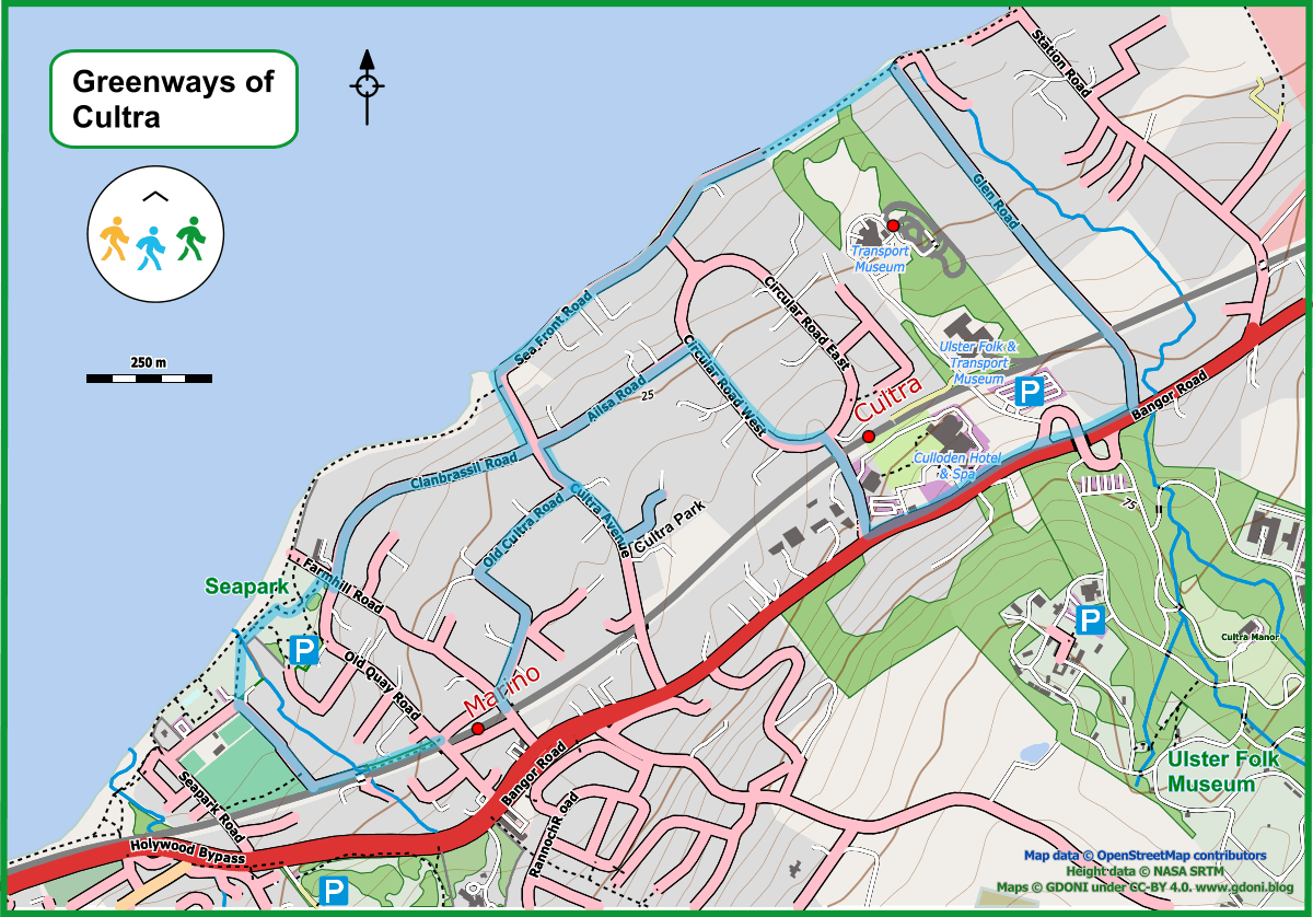
  • Greenways of Cultra

    Hidden paths and Wooded Demesnes

    Maps and photos note: click or tap to see any maps or photographs below as a high resolution version.

    Click or tap to zoom into map

    Summary 

    An alternative name for this walk might be ‘A Tour of the Grand Houses of Cultra’. A good place to start and finish this walk is at Marino Station – particularly if you are travelling by train to and from Holywood.

    It begins with a short bramble trail (the Black Path), down the side of the railway line which takes you to the coast and Seapark recreation grounds. It then guides you past some of the grandest homes in Cultra, built on the former Kennedy estate, and back to the coastal path for some great sea views before heading up to the main Belfast to Bangor road. Here you will pass the Ulster Folk and Transport Museum and Culloden Hotel before heading down to Cultra railway station and along more tree-lined avenues to your starting point at Marino Station. 

    The journey, at a fairly brisk pace, will take you about 75 minutes. 

    TYPECircular walk mixed suburban and coastal scenery. Footpaths and road walking with some climbing on roads but not too steep gradients. 
    DISTANCE3.65 miles / 8.1 km 
    SURFACESMostly asphalt paths and roads, but some walking on unsurfaced, potentially muddy, paths. Sturdy walking boots recommended in wet conditions and winter. 
    HEIGHT GAIN / LOSS120 feet climb 
    HAZARDSSome road walking on quiet suburban roads without pavements. The Black Path is narrow, muddy and quite uneven. Can be quite overgrown in summer with brambles and stinging nettles. Coastal path can be narrow in places with sheer drop down to beach. Risks in stormy weather. 
    (more…)
  • King John’s Progress

    Maps and photos note: click or tap to see any maps or photographs below as a high resolution version.

    Click or tap to zoom into map

    pro+gress n. ..6. Brit a stately royal journey.

    Collins English Dictionary

    To get to grips with a place it is necessary to escape its static present and seek out the flow of the natural and manmade landscape through time. When everything around you seems ordinary and now, you need to tease out the hints of history, to come to see the ground around you in a deeper dimension. Finding and travelling ‘the old ways’ is a means to do this and that is exactly what this walk tries to do!

    Holywood Motte today – with its ascending helical path added in the 18th Century
    TYPECircular walk mixed urban and countryside. Footpaths and road walking with significant climb and some steep gradients.
    DISTANCE3.2 miles / 5.2 km
    SURFACESMostly asphalt paths and roads, but some walking on unsurfaced, potentially muddy, paths.
    HEIGHT GAIN / LOSS470 feet climb
    HAZARDS
    • Some road walking on a quiet country road without pavements
    • One busy road crossing with limited visiblity
    • Steep slopes which could be dangerous in icy conditions
    (more…)
  • Urban Heights

    Maps and photos note: click or tap to see any maps or photographs below as a high resolution version.

    Click or tap to zoom into map
    TYPEUrban looped walk mainly along quiet residential roads. Significant climb up to the higher suburbs of Holywood
    DISTANCE2.9 miles / 4.7 km 
    SURFACESAlmost all asphalt paths along roads. One short section down uneven steps on a unsurfaced path which may be muddy. 
    HEIGHT GAIN / LOSS360 feet climb 
    HAZARDSTwo road crossing points on moderately busy roads with limited visibility which require care (see map). One short section along an unsurfaced path with uneven steps.

    What makes a good walk? I would go for green space, fresh air, great views, birdsong and a route with variety and interest along the way. We usually go to the countryside to find these things, but we can also get them in well designed urban environments and this butterfly shaped walk, through the high suburbs of Holywood, aims to prove the point.

    You can start this walk at any point on the blue line above – I have chosen to start at the Twisel Bridge.

    Live Map

    From here climb up the flight of steps to Victoria Road, crossing over with care and turning right. Follow around the corner past the entrance to Glenlyon House and continue to the junction with Ardmore Park.

    The “bathing villas” of Ardmore Terrace built around 1840

    Looking uphill you see a 3-storey house – the end terrace of a fine set of Victorian “Bathing Villas”. These were originally intended to be let as short-term seaside holiday homes, but longer term tenants were also welcomed.

     “Villas in Holywood at reduced rent. To let and immediate possession given, two houses in Ardmore Terrace. The houses have each a garden and the use of extensive grounds and contain Dining room, Drawing room and Seven Bedrooms with Hot and Cold Baths &c., and a never-failing supply of Water, without pumping. For a permanent tenant, very moderate terms would be made…An Omnibus plies from every Train, Fare 2d. Apply on the premises; or to James Greenfield, Post Office, Holywood.”

    Quoted in The Griffith’s Valuation fieldbook for the period (1856-64)

    Clearly the ability to commute easily to and from Belfast was as important then as now. However we are much more fortunate today in having ‘mains water’ and never having to worry about running dry!

    The row would have originally looked out over a large open space (where the houses of Ardmore Park now cluster) to an uninterrupted view of Belfast Lough and the Antrim Hills behind.

    The rest of the Terrace is two-storey

    Head up the hill and turn left to follow the front of Ardmore Terrace. The road runs to the end of the row and turns right to join Ardmore Road.

    You are now in a large area of mid twentieth century detached housing, primarily bungalows. There is much to admire here. Each house has generous gardens front and rear. There is a rich variety of garden trees, hedges and shrubs providing a shared space to enjoy for nature and walkers alike.

    The big windows and broad pitched gables are very much of their time although the building materials and technology originally used left something to be desired in terms of energy efficiency. However, with modern insulation and solar roofs these homes have everything needed to be state of the art 21st century eco-houses!

    Keep straight up Ardmore Road and a fine view of open country soon appears with a high tree-lined horizon. Turn right at the top T-junction with the appropriately named Ardmore Heights and continue up to the highest point of your walk (just under 300 feet above the sea visible below).

    As you come to the top corner of Ardmore Heights there is a cul-de-sac ending in Woodland. This is the upper part of Glenlyon Park. Unfortunately there is currently no path to access the park from here – but this would seem to be a great option for future recreational development.

    Continue along Ardmore Heights as it makes a full turn back towards Ardmore Road and Brown’s Brae beyond.

    As you proceed here it is very obvious you are dropping into a valley. Valleys generally have streams in their midst and here is no exception – the Croft Burn runs hidden, but un-culverted, behind the houses lining Ardmore Road below.

    Steep sided built-up areas like this are often a major cause of urban flooding when torrential rains cannot be accommodated by the limited capacity of the street drainage. However, here every garden, hedge, flower bed, lawn and shrubbery will act to absorb storm run-off and help spare other houses downstream the misery of flooding. This is in addition to cleaning the air, removing CO2, absorbing sound and providing essential habitat for birds and pollinating inserts. Neighbourhoods such as these are good neighbours indeed!

    Re-joining Ardmore Road I suggest to then take the next left up Glenview Road and then into Glenmore Avenue.

    Looking backward down Glenmore Avenue over Belfast Lough

    At the end of Glenmore Avenue you come to a pedestrian link path which takes you through to Glenview Road.

    The area was designed with houses with garages to accommodate the motor car, but it also provides good pavements and link paths for the use of walking humans. They are a balance and human focus missing in more recent developer ‘exclusive’ housing!

    As you arrive in Glenview Road a fine view over the lough and Antrim Hills opens up ahead. Glenlyon Park is just to your left but again there is no access possible here.

    Just before the interesting cluster of new houses at the end of Glenview Road turn right downhill into another pedestrian linkway.

    This takes you out onto Ardmore Avenue and then back down to Ardmore Road where you turn left and retrace to the far end of Ardmore Terrace.

    Look back now to admire the bold symmetry of the row. The houses are Victorian, but the simple geometries, balance and clean lines hark back to the Georgian style.

    Now don’t return down Ardmore Park but continue past the the terrace through a pedestrian link path bearing right onto Claremont Avenue.

    This is a much older roadway which takes its name from the large Victorian villa, Claremont House, which now sits on your left.

    As you descend pay attention to the electric power poles on your right. I imagine the old houses of Holywood were among the early adopters of electric home lighting and many of the old metal poles from that time have survived – still fit for purpose.

    Now cross Victoria Road, turn left and returning to the Twisel Bridge. Take particular care in crossing here as visibility is limited and traffic can be fast.

    Follow the Twisel path keeping an eye out for white chested dippers which sometimes can be seen bobbing in the burn below. You now emerge on Church Avenue which you follow out onto Church Road. turning right and continuing uphill to pass Glenlyon Park (you will have to cross the road as the left side pavement stops short).

    Further uphill, past the Glenlyon Car Park you turn into Plas Merdyn. This road is blessed with some of the finest views in Holywood.

    Near the road end you will see a set of old uneven steps with a rusty handrail dropping onto a narrow pedestrian path.

    Descend with care and follow the path, which can be muddy at times, down onto Demesne Grove, turning left out onto Demesne Avenue.

    Now turn uphill and to the road end where a path between high hedges takes you up to Demesne Park.

    There is a nice mixture of detailing in the houses here, reflecting in a small scale the fashions and thinking of their times. Open porches with decorative brickwork, high-pitched roofs, small oriel windows, stained glass and a low crisp white house with a curved metal window (which would not look out of place in a Poirot mystery).

    Turn right and follow Demesne Park around the corner and downhill.

    There are mercifully un-gobbled bungalows here, sitting on a height behind mature gardens. sporting bay windows with stained-glass top lights. Further down a respectful new-build sits nicely between its neighbours.

    Demesne Park now joins Demesne Road. Time for a little history.

    demesne (/dɪˈmeɪn/ di-MAYN) or domain was all the land retained and managed by a lord of the manor under the feudal system for his own use, occupation, or support.

    Wikipedia Demesne / Domain

    You might be forgiven for thinking that you are walking in the grounds of the original Holywood Demesne. However you would be wrong – at the closest point here you are over 200m from the once boundary wall.

    Holywood Demesne was the largest by far of the estates which encircled old Holywood Town. Inside its long gone boundary walls is now the Abbey Ring Estate, Sullivan Upper School, most of the Holywood Golf Course and Nun’s Wood – the North East section of the modern Redburn Country Park. Burns Community Pharmacy and Post Office now sit (approximately) on the site of Holywood House.

    So as you can see – it is not just artists who take licence with geography and history!

    Turn left along Demesne Road and then right into My Lady’s Mile (just opposite a nicely updated bungalow).

    Gaps in the big hedges of My Lady’s Mile reveal comfortable houses in generous gardens. However, the gap you are particularly interested in, is the entrance to a small pedestrian link path on your right which leads through to Lemonfield Avenue.

    This quiet cul-de-sac with an intriguing name joins through to the junction of Demesne and Downshire Road.

    To complete the looped walk now follow Demesne Road straight ahead, turn right onto Church Road and then almost immediately left back down Church Avenue to the Twisel Bridge.

    Route Map to Download and Print (PDF)

    External links

    back to top

  • Redburn Country Park Walk


    Please reuse this map but first see: https://www.openstreetmap.org/copyright

    The designation ‘Country Park’ suggests an accessible woodland on the urban fringe suitable for a gentle stroll. Redburn is not really like that and I have included 5m contours on the map above to make this clear. Any looped walk here will involve well over 100 metres of climb – a third of an Irish mountain and a significant workout for lungs, heart and legs! If you are of modest fitness be aware, take your time and pack in lots of stops to enjoy the great views which come with height and effort!

    (more…)